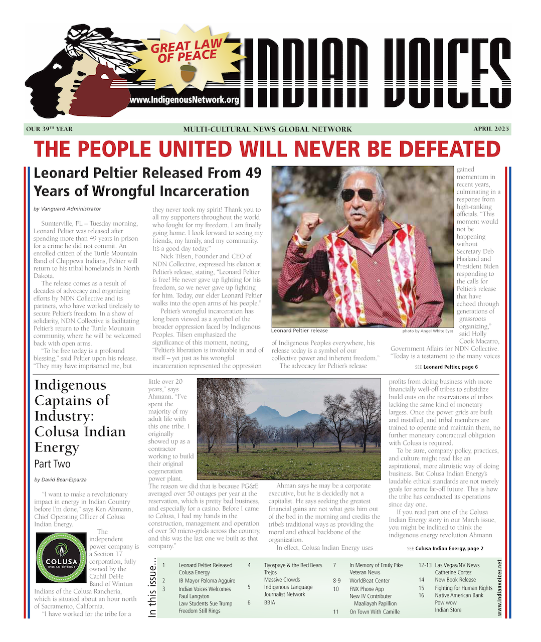
By Yvonne-Cher Skye
This is an introduction to the political climate within Oregon with a copy verbatim from the
Unratified Treaty Between the Federal Government and the Coast Tribes of Oregon.
Part 1.
Summary of the Treaty of land cession with commentaries, taken from Indian Land Cessions in the United States, an extract from the eighteenth annual report of the Bureau of American Ethnology, compiled by the Government Printing Office. Washington D.C.' reprinted in 1971 by Arno Press and the New York Times. Gleaned from the text: The Coquille Indians: Yesterday, Today and Tomorrow by Roberta L. Hall.
A. Description of the cession (page 812):
“Cede all title to the following lands: Commencing in the middle of the channel of the Columbia river at the northwestern extremity of the purchase made of the Calapooia and Mollala bands of Indians; thence running southerly with that boundary to the southwestern point of that purchase; and thence along the summit of the coast range of mountains, with the western boundaries of the purchase made of the Umpqua and Molallas of the Umpqua Valley, and of the Scotans, Chastes, and Grave Creeks of Rogue river valley, to the southern boundary of Oregon territory; thence W. to the Pacific Ocean; then northerly along said ocean to the middle of the northern channel of the Columbia river; thence following the middle of said channel, to the place of the beginning: Provided, however, That so much of the country described above as is contained in the following boundaries shall until otherwise directed by the President of the United States, be set apart as a residence for said Indians. And such other bands or parts of bands as may, by direction of the President of the U.S., be located thereon: Commencing where the northern boundary of the seventeenth range of township S. of the base line strikes the coast; then E. to the western boundary of the eighth range of townships w. of the Willamette meridian, as indicated by John B. Preston's “Diagram of a portion of Oregon territory;” then N. on that line to the southern boundary of the third range of townships S. of the base line; thence W. to the Pacific Ocean, and thence Southerly along the coast to the place of beginning. “
Does anyone here understand this? I have been trained on map interpretation and orienteering, and to be perfectly honest, I am flamboozled by the definition contained within the above text determining the land that the Oregon Coastal Indians ceeded to the United States Federal government.
But it gets, worse... “the money that these bands were given were determined to be expended for the use and benefit of the confederated bands, under the direction of the President of the United States, who may from time to time, at his discretion, determine what proportion thereof shall be expended for such objects as in his judgment will promote their well-being, and advance them in civilization, for their moral improvement and education; for buildings, opening and fencing farms, breaking land, providing teams, stock, agricultural implements, seed, ect. For clothing, in payment of mechanics, and farmers, and for arms and ammunition.” So in translation, the Indians were not capable of determining what to spend their money on, and had to be supervised by the President of the United States. Imagine if Donald Trump decides to use this power of his position.
This is verbage from one of the Treaty that has shaped the modern Oregon Coastal Indian landscape and by extension their access to resources and modern lifeways.
More information forthcoming...